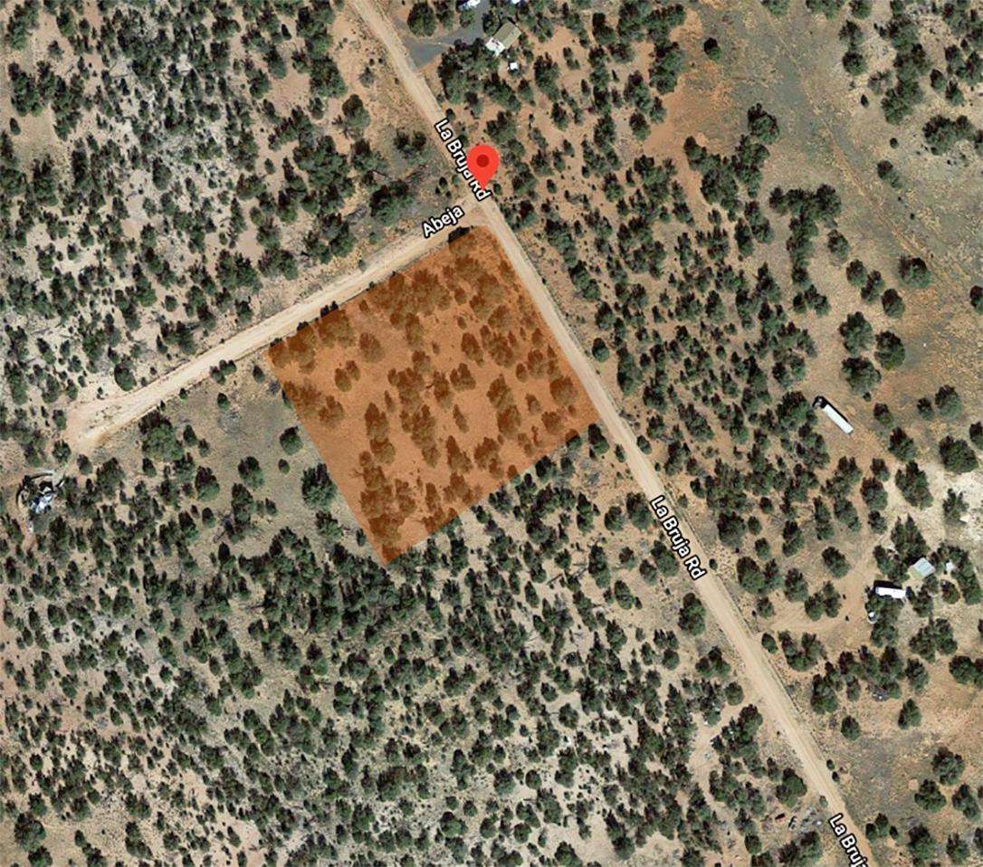
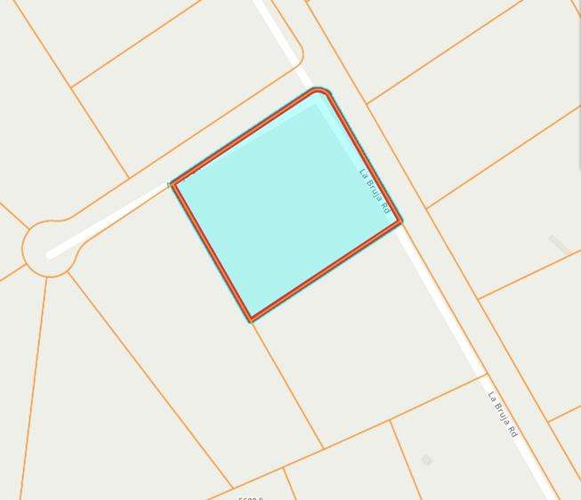
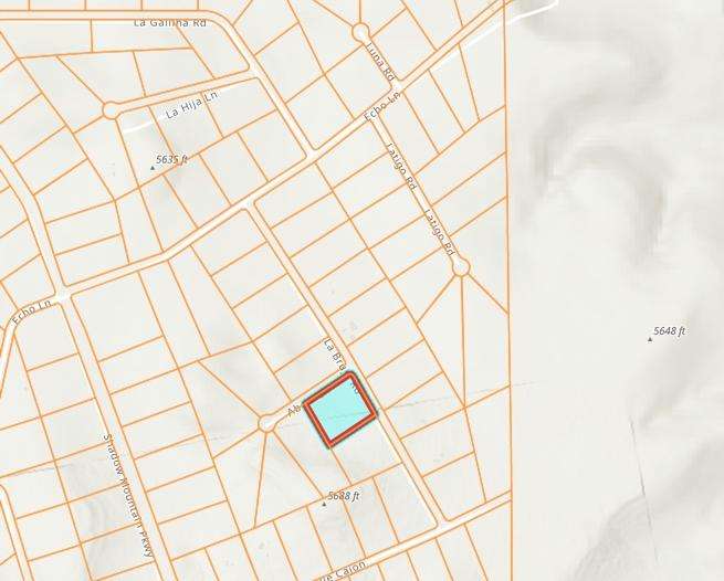
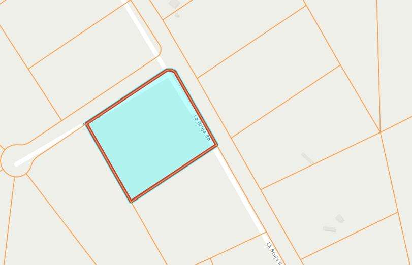
1.89 acres in Yavapai County, Arizona

Features
- Camping
- Fishing
- Horseback riding
- Hunting
- Off-roading
- RVing
Details
Hot property near Route 66
This hot property is located a short distance from Route 66 and close to Route 40. The area is upcoming and houses are being built on lots nearby. One is right across from this property. The beauty of this area is that you can enjoy the scenic beauty in your own privacy yet have a few houses around at some distance to keep in touch with community whenever you feel. We have priced this low and ready to sell with a great location.
More Photos coming soon…
Located close to town- just 15-20 mins! Seligman is the birthplace of Route 66, and the heart of America. This property has great views of open land and skies that rise up to the Black Mountain and more gorgeous mountains on other sides. This is prime desert land with diversity all around. To the north is Grand Canyon and to the South is Prescott- known for its art shows and festivities. The main city of Seligman is just a 20 min drive.
The property here is perfect for a getaway home or recreation in your own private setting with juniper trees and stunning mountains for company. There are plenty of things to do such as hunting, fishing, hiking, biking, photography and day-trips to the hottest spots in America- such as the Grand Canyon, Lake Mead, Flagstaff and more.
This is true American desert land with diverse beauty and moderate summers for year-round comfort. Easy to build your dream stay here.
From Kingman (WEST):
Get on I-40 E/US-93 S: 7 min (3.8 mi)
Head south on N 4th St toward E Andy Devine Ave/W Historic Rte 66: 292 ft
Turn left at the 1st cross street onto E Andy Devine Ave/W Historic Rte 66: 3.3 mi
From Prescott (South):
Take E Goodwin St and E Gurley St to AZ-89 N: 4 min (1.3 mi)
Head south toward E Goodwin St: 23 ft
Turn left onto E Goodwin St: 0.2 mi
Turn left onto S Pleasant St: 0.1 mi
Turn right onto E Gurley St: 427 ft
Continue straight to stay on E Gurley St: 0.1 mi
Continue straight to stay on E Gurley St: 0.7 mi
Follow AZ-89 N and I-40 W to Fort Rock Rd: 1 hr 21 min (78.7 mi)
Slight left onto AZ-89 N: 3.6 mi
At the traffic circle, take the 2nd exit and stay on AZ-89 N: 2.3 mi
At the traffic circle, take the 2nd exit and stay on AZ-89 N: 1.3 mi
At the traffic circle, take the 2nd exit and stay on AZ-89 N: 0.9 mi
At the traffic circle, take the 2nd exit and stay on AZ-89 N: 3.8 mi
At the traffic circle, take the 2nd exit and stay on AZ-89 N: 0.8 mi
At the traffic circle, take the 2nd exit and stay on AZ-89 N
Pass by Dollar General (on the right in 3.0 mi): 3.8 mi
At the traffic circle, continue straight to stay on AZ-89 N
Pass by McDonald’s (on the left in 0.2 mi): 1.3 mi
At the traffic circle, take the 2nd exit and stay on AZ-89 N: 32.5 mi
Turn left to merge onto I-40 W: 24.8 mi
Take exit 121 for I-40BUS Loop toward AZ-66/Seligman/Peach Springs: 0.3 mi
Turn right onto I-40BL E: 1.1 mi
Turn right onto AZ-66 W/W Historic Rte 66 (signs for Peach Springs)
Use the right lane to merge onto I-40 E/US-93 S via the ramp to Flagstaff/Phoenix
Follow I-40 E to N Anvil Rock Rd in Yavapai County. Take exit 109 from I-40 E: 50 min (55.6 mi)
Merge onto I-40 E/US-93 S
Continue to follow I-40 E: 55.3 mi
Take exit 109 for Anvil Rock Rd: 0.3 mi
Take Fort Rock Rd, Via De Oro Pkwy and Shadow Mountain Pkwy to La Bruja Rd: 23 min (8.5 mi)
Turn right onto N Anvil Rock Rd: 410 ft
Turn left onto Fort Rock Rd: 4.0 mi
Turn left onto Via De Oro Pkwy: 1.2 mi
Continue straight onto Va De Oro: 0.3 mi
Continue onto Via De Oro Pkwy: 0.2 mi
Turn right onto Conquistador Pkwy: 0.2 mi
Continue onto Conquistidor Pkwy: 0.4 mi
Continue onto Conquistador Pkwy: 0.2 mi
Turn left onto Fleetwood Dr: 0.4 mi
Turn left onto Sunset Dr: 479 ft
Turn right onto Shadow Mountain Pkwy: 1.0 mi
Turn right onto Cll Cajon: 0.3 mi
Turn left onto La Bruja Rd
Approximate Distance to Nearby Cities & Points of Interest:
20 minutes to Seligman, AZ
45 minutes to the Grand Canyon Caverns
58 minutes to Williams, AZ
1 hour to Kingman, AZ
1 hour 38 minutes to Prescott (via I-40 E)
1 hour 25 minutes to Flagstaff, AZ
1 hour 45 minutes to Diamond Creek Beach on the Colorado River
1 hour 45 minutes to Grand Canyon National Park
2 hours to Sedona (via I-40 E)
2 hours 10 minutes to Lake Mead
2 hours 25 minutes to Humphrey’s Peak (highest point in Arizona)
—
Subdivision: Bridge Canyon Country Estates.
HOA/POA: No
Improvements: None
Water: by well or holding tank
Sewer: Would be by Septic
POLYGON DATA (GPS Coordinates):
35.3506046010315,-113.031027321339 ;35.3506053019185,-113.031041536569 ;35.3506038220518,-113.031055692137 ;35.3506001898329,-113.031069347257 ;35.3505945181067,-113.031082092009 ;35.3501386491644,-113.031917390011 ;35.3494643850965,-113.03144600067 ;35.3499582520575,-113.030541099975 ;35.3505712191215,-113.030969630023 ;35.3505812856925,-113.030978120909 ;35.3505898875008,-113.030988474094 ;35.3505967777496,-113.031000377036 ;35.3506017300073,-113.031013459163 ;35.3506046010315,-113.031027321339
Game
Antelope
Property Tax Exemption
No
Proposed Use
For Development
Mobile
Residential Single
Road Frontage Desc
Dirt
Utilities:
Alternative Energy (Solar, wind, or generator).
Phone would be cellular or Satellite.
TV/Internet would be Satellite.
- ID: 3666
- Views: 303


